Published 14 July 2020 ● Last Updated on 15 July 2020
Today’s article comes from the pen of walkaholic Sulata Maheshwari. Sulata’s love for hikes comes from long Indian summers spent in its villages. The love was rekindled in the terrains of Japan, nurtured in the mountains of Hong Kong and has kept growing in the green plains of Singapore. A regular of the Park Connector Network (and the eateries that abound around this ecosystem), she has left footprints throughout the Red Dot in walks that range from an hour to a day long. Having seen the best hiking in Singapore, she shares her picks below so you can take to the road in the most exhilarating, fat-burning… and eco-friendly way to travel!
My family’s weekends in Hong Kong were mostly spent hiking in the mountain trails- quiet, zigzagging the play of light through the trees, unending steps taking us down before taking us higher and higher. Till we could see the cool blue ocean, sparkling with the rays of the golden sun. The breeze blowing our hair and a sheen of pure bliss stretching to eternity.
When we moved to Singapore, I wondered whether I may find a hill in an undiscovered corner (though the voice in my head asked, “How big do you think the city is, that you will find undiscovered trails and secret places to hike in Singapore?”) Yet a fool’s paradise resides in hope; so I hoped.
They say nature reaches out to its true admirers. When a friend proposed a walking group to help train for her Everest Base Camp hike, I did a little dance in my mind. Together, we explored the corners of Singapore, hiking with the aid of maps and directions provided by National Parks. We first started with a few well-known nature trails like MacRitchie Reservoir, Southern Ridges, Fort Canning, etc. We soon realised there is more than what is charted out in the individual trail links. And yes, there are ways to train for a trek in Singapore!
Random Aimless Walking around (no, it doesn’t indicate madness) is hugely beneficial to mental health and leads one to the joy of discovery – even in an overly explored place like Singapore. Here are 3 picks from my favourite walking routes in Singapore, covering different parts of our island nation. Have you explored any/all of these, and their loopy detours? Here’s to walking the roads we haven’t traveled, and finding zen in nature!
P.S. Bookmark this link to avoid crowds when you head out!
“There is a pleasure in the pathless woods,
There is a rapture on the lonely shore,
There is society, where none intrudes,
By the deep Sea, and music in its roar:
I love not Man the less, but Nature more,”
– Lord Byron
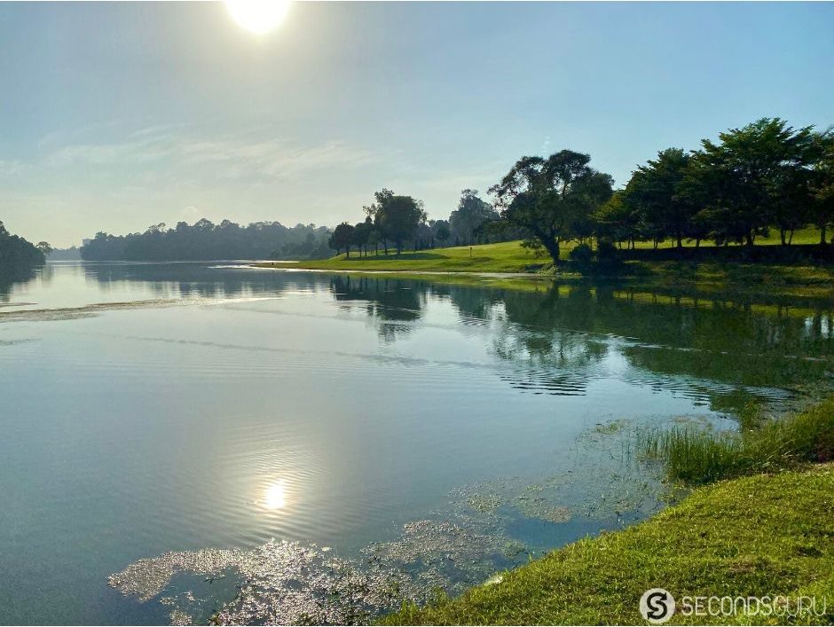
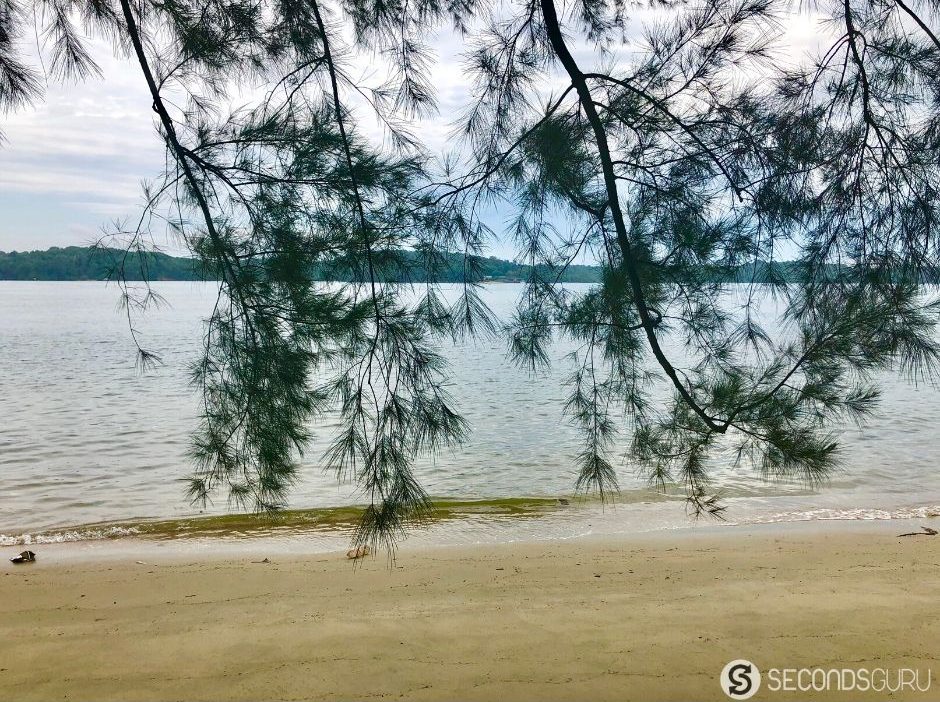
Windsor Nature Park plus MacRitchie with Treetop Walk
Start Point: Windsor Nature Park Carpark
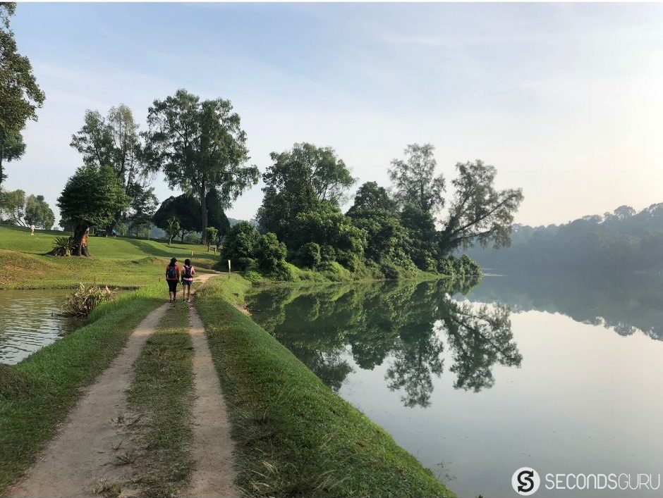
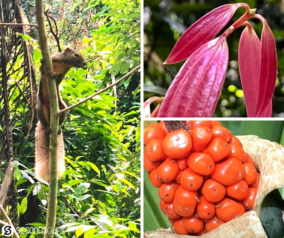
As soon as National Parks declared Windsor Nature Park open in April 2017, I set off on this one on my own. Fresh wooden boards, quiet and peace. Little slivers of sun streaming through the thick foliage. And a small stream full of small aqua creatures in the Squirrel Trail. You get the picture – this trail is for the forest lover!
After a couple of tries, I figured out a way to make it a good loop without having to repeat too much of the trail. Some route tips that you can read with reference to the map below: When you are first exploring, take the Venus Loop (direction towards Squirrel trail), but ignore the Squirrel Trail’s turn to your right and go straight ahead. When you reach a Y crossing on the trail (after leaving Squirrel trail) – take the path left-wards and you will find yourself in a less curated, more overgrown, small rustic trail.
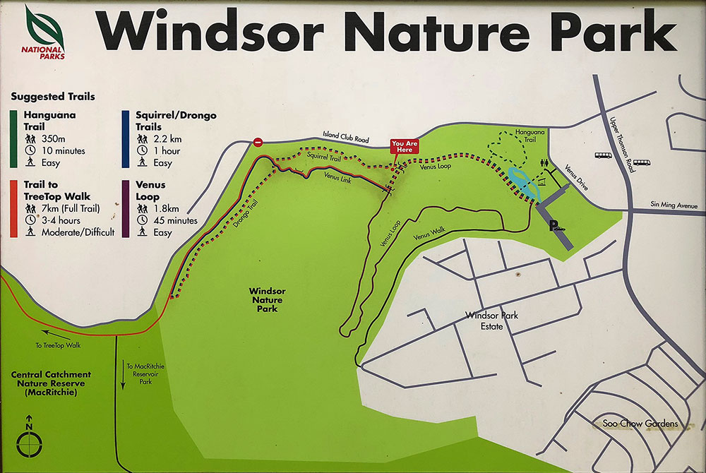
As you go through this secluded rustic track, you will find yourself back to where you started. Repeat the trail and this time proceed onto Squirrel Trail. When you see it, do turn towards the Drongo Trail and proceed to Treetop Walk. When you finish the Treetop Walk, you will reach Petaling Hut, with a choice to turn right or left. Roughly the same distance to the car park either way, so toss a coin and go!
ROUTE MAP LINK: Windsor + Treetop + Jelutong (right) or Windsor + Treetop + Petaling (left)
In either case, You would have done roughly 12kms/2.5hrs.
Eating: The local cafe at MacRitchie has very limited options though the coconut water is refreshing. We normally head to the nearby Adam Road food court for yummy options.
Shorter Trail:
Instead of doing Treetop Walk from Windsor Nature Park, just go towards MacRitchie Reservoir Car Park.
Longer Trail:
If you are like me (remember, Random Aimless Walking around?), you will do this trail. Walk from Windsor Nature Car Park, turn right for Hanguana Trail, Venus loop, take the Squirrel Trail, Drongo Trail, Treetop Walk, turn right at Petaling Hut towards Jelutong Tower, do the full loop of MacRitchie Reservoir till you reach the point showing Windsor Nature Park. Proceed towards Windsor Nature Park on the Drongo Trail. Do not take the Squirrel Trail, take the path to the right of it till you reach the small rustic overgrown path pointed out earlier – this will be to your right. Follow it till you come out again to Windsor Nature Car Park.
ROUTE MAP LINK: Windsor + Treetop + full MacRitchie + Windsor
You would have done roughly 17-18kms/3.5hrs.
Trivia: If you have the time, Squirrel Trail, has the most amazing display of squirrel activities and the healthiest lot of them.
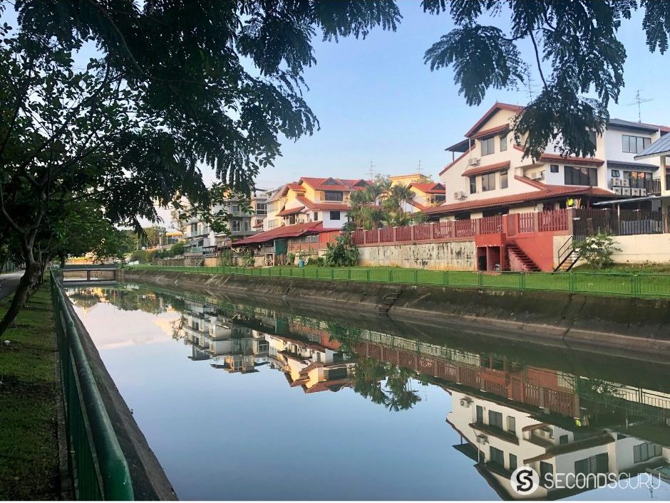
Punggol Park with Coney (Serangoon) Island
Start Point: Punggol Park
This walk covers pin-drop silent beaches as well as bustling neighborhoods, providing an insight as to what Singapore means when it declares ‘City in a Garden’ as its motto.
Start from the Hougang Ave 10 entrance to Punggol Park. If you are taking a cab, get dropped off at Punggol Park Community Centre and crossover. Turn right here to follow the trail around Punggol Park. It is a beautiful park with inspiring seniors all around. Take a full round of the park all the time keeping close to the water on your left till you reach Punggol Park Fitness Corner. At this point, just cross over to the trail at the side of the canal, turn right and follow the canal trail.
Soon you will reach a point where a brown board will direct you to Punggol Promenade. Keep on the trail till you reach Lorong Halus bridge, a bright red bridge on your right. Cross the bridge and turn left till you reach a T-crossing showing left for Coney Island. One can cross straight across the island using the main road like the backbone. Instead, turn right to all the rustic trails, dotted with the cutest little beaches. As much as possible, stay to the right trails when possible. When you come out of the Coney Island’s West Entrance/Exit, go to the main promenade and turn left. Follow the trail straight on till you see your dear old bright red bridge and you know your way back to Punggol Park.
ROUTE MAP LINK: Punggol Park + Coney Island
You would have done roughly 18 kms/3.5 hrs
Eating: Food Court behind Punggol Park Community Centre.
Shorter trail: One option is to take a right from the Coney Island West Entrance/Exit and reach the Punggol Settlement. Another option is to take a left after leaving Coney Island, and soon after the red bridge , you will find cafe Whisk and Paddle to your right. It is open weekday (evenings) and weekends (all day) so that can be a pit-stop. Or Google map your way to Punggol Plaza (nice food court – but even nicer are the robots that clear your food trays!)
Longer Trail: Instead of crossing over towards the Red bridge on your way back, turn right and continue ahead to cover the very pretty Punggol Waterway Park and loop back from there towards Punggol Park. Or continue following the Coast to Coast Trail markers to reach Yio Chiu Kang Road. This stretch is one of the most beautiful semi-urban trails I have done with beautiful kampung-style houses. I find Buangkok Square Mall a good place to rest and grab my favourite food court bites.
Trivia: A band of monkeys in Coney Island are better trained than urban human kids to open bags, take out food and eat them. Keep everything well zipped in.
Marina Barrage – Puppy/Unicorn Trail
Start Point: Tanjong Rhu Suspension Bridge
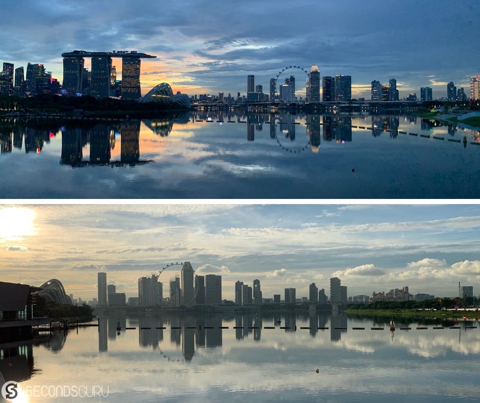
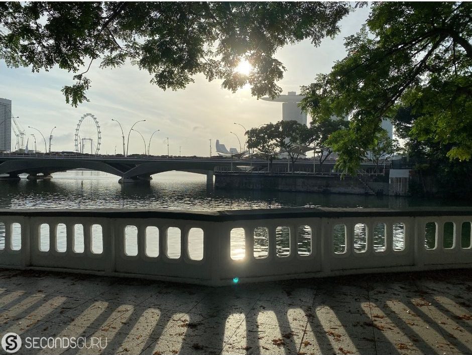
This is an urban trail which delights at morning, noon or night! Arguably the best way to enjoy our expanding skyline, the pit-stops include Singapore Flyer, Arts and Science Museum, Boat Quay, Helix Bridge, the entire promenade from varying angles, and more.
As an east coast resident, I prefer to start at the Tanjong Rhu Suspension Bridge, and that’s the route I detail ahead (and you can move your starting point to your liking by referring to the map link later on!). Begin on the Tanjong Rhu side of the bridge and follow the Park connector Network keeping Geylang River to your right. Cross Marina Barrage, head to Marina Bay Sands (MBS). Follow the promenade walk, passing by Helix Bridge (do not cross it), Art Science Museum, and the whole length of MBS. You need to reverse direction now – so go towards Customs House to walk the opposite side of the promenade trail, heading towards Merlion. Cross the Esplanade Bridge and turn right to continue on the waterfront. You will pass by Esplanade, go under the Helix Bridge, pass by Singapore Flyer, F1 track as you go onto Marina Promenade.
Marina Promenade is akin to a small stretch of Hawaii – with the coconut trees stretching into the blue sky and the water sparkling in the expanse as Geylang River meets Marina Bay. Follow the trail under Merdeka Bridge (Nicoll Highway). Walk a while keeping Rochor River to your right and you will find a pedestrian underpass taking you to Kallang Riverside Park. Take the underpass (this allows you to cross the bridge) and turn right to reach Kallang Riverside Park.
Continue by the water (Kallang River), till you reach Kallang Road. Cross the bridge to the right and turn into Old Terminal Ln from Kallang/Geylang Road. Follow the promenade till you reach OCBC Aquatic center. You are almost back. Keep National Stadium to the left and follow the waterfront, cross the Tanjong Rhu Bridge to finish. However, before that, you should eat to your delight at Kallang Wave Mall.
ROUTE MAP LINK: Marina Barrage – Puppy Trail
You would have done roughly 15-16 kms/2.5-3 hrs.
Eating: Kallang Wave Mall. Love the Kaya toast, Otah and Teh at Fun Toast, Chicken Curry Rice at Old Chang Kee and Back Olive Rice at Thai Basil.
Shorter Trail: After crossing Marina Barrage and Gardens by the Bay, take theHelix Bridge to walk across. A walkway just below the Helix bridge exit allows you to join the Marina Promenade straight away. Carry on with the trail as suggested earlier.
Longer Trail: From Merlion, turn left to follow the waterfront in Boat Quay. You have to do a quick Fullerton road cross to move to the other side. Keep going to Merchant Loop, Alkaff Quay till you reach Saiboo Street/Pulau Saigon Bridge. Cross it and make your way over to Common Man Coffee Roaster. Enjoy the best of coffee, then head back to the bridge, turn left and continue on the other side of the water till you come all the way back. This will be the Unicorn Trail (Map link).
Trivia: The most scenic photos will come in this route, whether you walk at sunrise or sunset or bang in the middle of the day (don’t be crazy it is way too hot!).


0 Comments