Published 30 April 2021 ● Last Updated on 3 May 2021
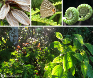
Today’s article – our second in the series – comes from the pen of walkaholic Sulata Maheshwari. Sulata’s love for hikes comes from long Indian summers spent in its villages. The love was rekindled in the terrains of Japan, nurtured in the mountains of Hong Kong and has kept growing in the green plains of Singapore. A regular at the Park Connector Network (and the eateries that abound around this ecosystem!), she has left footprints throughout the Red Dot in walks that range from an hour to a day long. Having seen the best hiking in Singapore, she shared 3 of her favourites in this article earlier, and now lists a few more below so you can take to the road in the most exhilarating, fat-burning… and eco-friendly way to travel!
I walk when I am sad – I come back home happy.
I walk when I am happy – I come back home happier.
The above summarises my love for walks. I love walking with friends. I also love walking alone – I am, however, never alone in trails. My friends from nature always tag along. The little dances of dragonflies and damselflies, the tangos of painted jezebels, the slithering away of glittering copper or bronze coloured salamanders… I always have company. When I once was lost in Pulau Ubin, a little doggie showed me the way out.
I have also found truly friendly humans on trails – people happy to befriend me though we’ve never met before. Some have shown me a new path which excited them, some have warned me of dangers ahead, some have shared their joy of spotting a strange bug…. I am never alone. I am also lucky to have like-minded friends who have been walking with me for years, not for an exercise regime but because they truly enjoy nature and the trails of Singapore invigorate that love. The best therapy one can get is to quietly share a trail experience with a friend.
My average walking is around 8.5kms per day for the year, which is not much but I strongly believe in not wearing oneself out. (Editors’ note: We respectfully disagree. Clocking over 3000 kms in 2019 is jaw-drop-worthy in our book!) From the myriad trails I have thus enjoyed, below are some gems (and their detours) for those of you are itching to explore Singapore – including the marathon-length Coast to Coast walk. Bookmark them in addition to my previous recommendations of some of the best hiking trails in Singapore!
Chestnut Park with Central Catchment Park Connector
Start Point: Chestnut Nature Park Car Park
This is a trail I have walked with friends in pouring rain! Around 8 of us, under 8 colourful umbrellas, wearing hiking shoes, splashing through the mud in ankle-deep water. None other than us on the trail.
To follow our footsteps: Walk down Chestnut avenue from the car park. You will cross an entry to the park on your left, ignore it, go further down. When inside, take the path to the right (shown by the red star) and follow the trail – You are entering the Southern Loop.
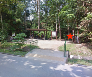
After around 2kms, you will loop back to Chestnut Avenue (further down). You have finished the Southern Loop – time to simply cross the road and continue the trail on the other side. When you reach a paved road, which is part of the trail, turn right and you are now entering the Chestnut Northern trail.
At any point, stay to the right of the track. If you follow the trail correctly, you will reach an observation tower to your right. You will also find a crossroad (cross-trail) here. Do not turn right or left, just go across and continue on to the red star marked trail (photo below).
This is a beautiful unpaved trail. When you reach a sort of T-junction, turn to the right to continue the trail. Keep left mostly to reach Mandai Road. You can turn back at this point till you retrace the whole trail, while looking for directions to Chestnut Point. Try not to take any left turn to enter the Southern trail back again 🙂 No harm if you do, you will end up adding another 3/4 kms to your journey.
Eating: Unfortunately, nothing that we found nearby. A cab/bus is your best option.
You would have done roughly 14-15 kms/3hrs.
ROUTE MAP LINK: Chestnut Nature Park + Central Catchment
Shorter trail: Finish at Mandai Road.
Longer Trail:
Combine the trail with Zhenghua Park, whose midpoint entry is in Chestnut Avenue, very close to the carpark and continue to Dairy Farm Nature Park. There is another entry to Zhenghua Park from Central Catchment trail. Let that remain for you to explore and find out. Hint: The place where I told you to turn neither left nor right – take a left there for the alternate entry!
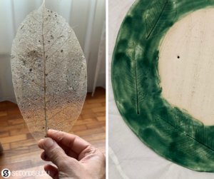
Trivia: If you pay attention to the fallen leaves in the Central Catchment trail, they are a perfect mesh post decomposition. A friend used it in her pottery impression to wonderful effect.
Rifle Range plus MacRitchie
Start Point: MacRitchie Reservoir Carpark.
MacRitchie was a favourite haunt for my group walks, where we usually followed a familiar circuit. Every time we passed by the nondescript track left of the rock saying Sime Track, a childlike curiosity would take over me. Dare to take a detour and explore, it urged; wouldn’t you too want to discover secret places to hike in Singapore?
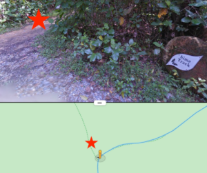
So I did. And if you do too, you will be welcomed by a beautifully isolated (this word has a different connotation nowadays, the one I am referring to is beautiful isolation among nature) trail. At any point in the trail you have a doubt, keep to the left.
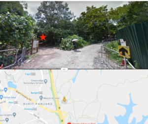
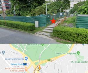
Keep following Rifle Range Road, and you will finally reach civilisation with a few small houses and a big road (Jln Anak Bukit). Take the steps to the right (shown by the red star in the photo below) to reach a bus stop next to a flyover. Cross the flyover and you will find yourself warmly welcomed by Bukit Timah Plaza where you can grab a bite and enjoy the air conditioning.
Eating: The small eatery in the basement having chicken curry-rice, prata, kaya butter toast and lemon barley has been our usual haunt.
You would have done roughly 10kms/2hrs.
ROUTE MAP LINK: Macritchie + Rifle Range
Longer Trail:
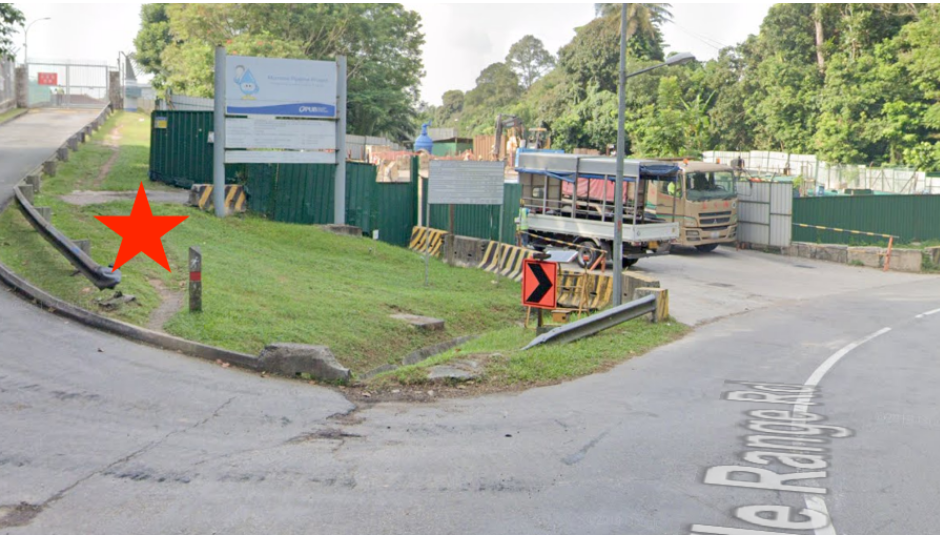
For a while follow Rifle Range road, beyond the monkeys and you will reach here (photo below). Take the unpaved path to the left (red star), follow the uncharted path by the barricaded wire mesh of PUB works onto the road Jln Kampong Chantek till you reach Kampong Trail – a small entry from the road to the right. Enter the jungle of Kampong Trail, Durian Loop and do not get on the road (Rifle Range/RR) till you reach Bukit Timah MTB Trail. After that, it is the same exit as above.
You would have done roughly 11kms/2.5hrs.
ROUTE MAP LINK: Macritchie + Rifle Range + Kampong
Pls check whether Kampong Trail is open before heading out on the red star path – though you can always back trace a few hundred meters and get back to Rifle Range road.
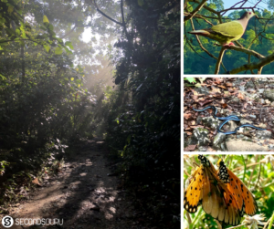
Trivia: Creepy crawlies abound. My friends had abandoned me among chameleons, snakes and even invisible creatures to dash for life. I, however, thrive observing their beautiful camouflage, Fibonacci patterns in their wings and many such beauties that only nature can provide.
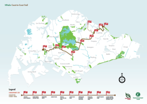
Coast to Coast (C2C) Trail
Start Point: Coney Island West Entrance
My walks typically serve either of 2 purposes: natural beauty with unique flora fauna or physically challenging. The C2C trail is one serving the latter. In my walking group’s last attempt, we finished it in 7 hours and felt happy with the accomplishment. If you are wondering where can you trek in Singapore, this is not a trek – but it will give you the stamina challenge!
C2C is a challenging trail for two reasons. One, it is long. I have done this trail 5 times now and it is closer to 40kms than 36kms as told by NParks. Two, a lot of it is on the roads (paved, concrete) which becomes painful for the foot and the heat of Singapore doesn’t help. So a few basics before you start on this:
1. Start early: After our first attempt, which we ended halfway, we start at 5.30am from the trail head.
2. Start Point: The start point designed by NParks is Jurong Lake Gardens. We tried that the first time and realised it is better to start from Coney Island. You don’t face the sun, it is behind you.
3. Gear: They say, there are no poor conditions, only poor clothing. Wear lightweight but proper cushioned shoes, in good condition, so your feet are protected from the long concrete walk. When feet start feeling heavy, it is difficult to move on. Keep a light rain jacket as rains in Singapore are quite whimsical. Fruits and energy balls (grounded dates, sesame, nuts) are the best to carry – heavy food like sandwiches are tough when you are on a long road. Make sure your clothings do not chaff anywhere.
Right outside the West Entrance of Coney Island, you will find the Coast-to-Coast trail map and brown/green board. Take the customary selfie with it and set off. Follow the big white banners, the boards and C2C app, which will indicate the route to take.
Till Macritchie Reservoir, this is the ROUTE LINK to follow.
After this, keep following the route maps as NParks have opened up the newly done stretch from Macritchie to Kheam Hock Park. Keep to the right of Lornie Road (not Lornie Highway) and follow the route boards. The road takes you on a curve out towards the left. Follow the curve till you face an overhead pedestrian bridge crossing Lornie Highway. Cross the bridge, keep Lornie Highway to your right and proceed. You will continue seeing the route boards on the other side showing the next destination as Kheam Hock Park.
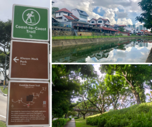
From the bus stop at Lornie Highway, follow the direction and turn to Kheam Hock Road by the cemetery to reach the park. You will cross the interesting lane Lor “Halwa” which caused some of us to salivate (do try the Indian sweet by the same name if you are wondering why!).
From Kheam Hock Park, lookout for the C2C boards and banners to follow the trail – a brown path will lead you out of the Park in the right direction towards Adam Road (to your right). Soon you will reach Adam Road Food Centre (CheckPoint 4). If your footwear has not given way by now, follow the route map and banners towards Botanical Gardens. Do not enter, just turn to Bukit Timah Road and follow the trail. After BT Nature Reserve, it is a very pretty part of the trail, less stressful as the markings do not create much confusion and soon you will reach CheckPoint 1. The CP 1 is not inside Jurong Lake Gardens, it is earlier, so pls follow the trail direction. It is a beautiful trail and you will be surprised when the CP1 pops up in front as you are busy admiring the Chinese Garden opposite the water. You would have done around 40kms by now.
If you, like some of my crazy friends, have a hankering for completing Marathon distance, pls keep walking to Jurong Lake Gardens till your app clocks that distance.
Eating: A kind man told us to head to Boon Lay MRT for eating options. We obeyed and were rewarded by a lunch at Din Tai Fung.
You would have done roughly 42.5 kms/7-9 hrs.
Shorter Trail:
Stop at any point. The first time we tried, we had to stop at Macritchie Reservoir, roughly halfway of the trail.
Longer Trail: Seriously?? Hit the mountains.
PS: Do read and follow way more details than given at NParks guide/app for this trail. I have just tried to point out a few things we missed and our learnings from our 5 times on this trail.
Trivia: We have worn out of shoes, fought with each other, crossed non-crossings, ran out of water and of course ran out of steam, while doing this trail. Felt very fulfilled each time we did complete and forgot the rows over which side the damn arrow on the board is pointing.
Related Articles
From screen to green | Tips for connecting children with nature

0 Comments